Geospatial Data Analysis with Machine Learning
Feel free to send me your offers, inquiries, and project details, and lets discuss the best support I can provide for your geospatial and machine learning needs.
Example Services:
- Suitability mapping: such as crops, habitats, soil nutrients, or ecosystem services.
- Risk prediction: such as fires, deforestation, emissions, floods, or subsidence.
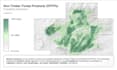
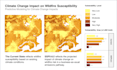
- Climate impact modeling: such as integrate SSP scenarios to assess the potential impacts of climate change.
- Land Cover/Use classification.
Example Processing:
- Sample pre-processing: clean, standardize, and reduce spatial autocorrelation in your data.
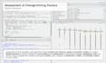
- Predictor collection & selection: apply methods like Pearson correlation, VIF, and recursive feature elimination.
- Hyperparameter tuning: optimize model parameters using techniques like grid search or Bayesian optimization.
- Model selection & validation: split data, perform spatial cross-validation, and ensure reliable results.
- Comprehensive reporting: receive detailed reports with scientific analysis and infographics.
Tools: R, Python, Google Earth Engine.
Model: Random Forest, XBoost, MaxEnt, SVM, kNN, and ensemble model.