Browse categories
Explore
Fiverr Pro
English
$
USD

Transform your drone photos into accurate maps & 3D assets
I convert drone photos into accurate maps and 3D assets for engineering, construction, and environmental projects. I work with Pix4D, Metashape, ArcGIS Pro, and QGIS, integrating GCPs/RTK for reliable accuracy. Clear deliverables, tidy layers, and honest QCevery time.
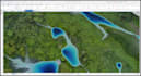
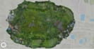
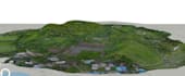
Have raw drone/UAV images? Ill professionally process them into georeferenced orthomosaics, DSM/DEM, point clouds, contours, and textured 3D modelsready for GIS, CAD, and planning workflows.
What I Deliver
Common Uses
Accuracy & Workflow
Please inform the freelancer of any preferences or concerns regarding the use of AI tools in the completion and/or delivery of your order.
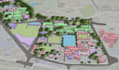
Innovative GIS Solutions for Smarter Planning
Languages
Q1: What if my images have low overlap?
I’ll assess feasibility first. If coverage is marginal, I’ll propose a reduced AOI or ask for re-flights to maintain quality.
Q2: Can you handle heavy canopy or water surfaces?
Yes, with caveats. Vegetation and water can reduce tie points; DEM quality may vary. I’ll apply filters and classification, and include notes in the report.
Q3: Can you use my GCPs or RTK?
Absolutely. Provide coordinates, CRS, and marker visibility. I’ll include an accuracy summary (RMS, checkpoints).
Q4: What formats do you deliver?
GeoTIFF (mosaic/DSM/DEM), LAS/LAZ (point cloud), SHP/DXF (contours), OBJ/FBX/PLY (3D mesh), PDFs/PNGs for maps/legends, and a short report.
Q5: Can you do contours at a specific interval?
Yes—common intervals are 0.25 m / 0.5 m / 1 m (or 1 ft / 2 ft). I’ll smooth intelligently and keep hydrology-safe breaks.
Q6: My files are huge—how do I share?
Share via Google Drive/Dropbox/WeTransfer. I’ll return organized deliverables with a simple folder structure.


