I will be your geospatial research and analysis partner

Canada

I speak English, French

50 orders completed

Geospatial wizardry: analyze, code, export, repeat!

With over 10 years of experience in remote sensing, spatial analysis, and geospatial project coordination, I hold a Master's in Geography, an MGIS degree, and a CAPM® certification. I specialize in ap...
About this Gig

I am here to help with your research in forest & vegetation analysis, wetland mapping, disaster risk, climate impact modeling, urban spatial analysis, and related spatial topics.


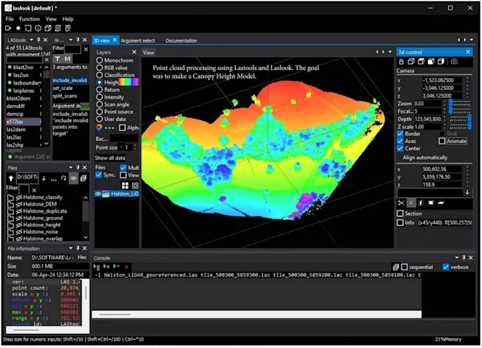
I am an expert in spatial analysis, remote sensing, spatial DB ops, Web GIS, and cartography, with 12+ years of experience based in Calgary. I have an MGIS from the University of Calgary, Alberta, and an MSc in Geography.


I have extensive experience in topics, including (but not limited to)

  • Advanced Remote Sensing: Multispectral/ hyperspectral/ radar/ point-cloud data processing for forest, agri, wetland, and urban ecosystems using desktop (ie, ArcGIS, Erdas Imagine, eCognition, etc.) and cloud-based environments (ie, GEE)
  • Spatial scripting: Python (ArcPY, GeoPandas, Rasterio, Xarray, etc.), R (sf, tidyverse), and Google Earth Engine
  • Research write-ups and tutoring: Research articles, technical reports, manuals, blogs, and tutorials.


Why should you hire me?

  • Experienced observations and quick delivery
  • Prompt feedback and support tailored to the individual client
  • Customized work packages and consultation


Please chat before ordering.

My Portfolio