Browse categories
Explore
Fiverr Pro
English
$
USD

Need clear, professional GIS outputs for an environmental, planning or research project?
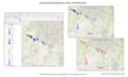
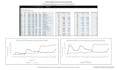
I use QGIS to create accurate maps, spatial analysis, graphs and report-ready figures tailored to your project.
Services can include:
Depending on the package, you can receive high-resolution PDF or PNG maps, graphs, editable QGIS project files, processed spatial data, a short methodology summary and a narrated results presentation.
Each output is manually checked for coordinate-system consistency, scale, legends, layout and overall clarity.
Please contact me before ordering Standard or Premium so I can confirm the data, scope and correct package.
This service does not include statutory approval, regulated professional certification or formal sign-off.
Environmental GIS and Data Analyst
Languages
What information do you need before starting?
Please provide the project area, purpose, required outputs, preferred style and any available datasets, coordinates, spreadsheets or reference maps.
Can you source and prepare GIS data?
Yes. Data sourcing, cleaning and preparation can be added as an extra service. Please contact me first so I can confirm suitable datasets are available.
What file formats can you deliver?
Depending on the package, I can provide PDF, PNG, JPEG, QGIS project files, GeoPackage, shapefile and processed spreadsheet outputs.
Can you create graphs and explain the results?
Yes. Standard and Premium packages can include relevant graphs. Premium also includes a short narrated presentation explaining the main methods and findings.
Do you complete university assignments?
No. I can provide legitimate GIS support, visualisation, tutoring and feedback, but I cannot complete assessed work intended to be submitted as someone else’s own.


