Browse categories
Explore
Fiverr Pro
English
$
USD

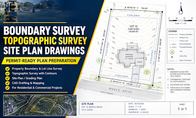

Need accurate boundary survey, topographic or site plan drawings for your property or permit application?
I will prepare detailed land survey and site plan drawings based on your supplied survey data, measurements, sketches, PDFs and existing plans.
My services include:
I prepare organized drawings using AutoCAD and other relevant CAD workflows, with attention to dimensions, layers, clarity and project requirements.
Whether you are a property owner, contractor, architect, engineer or developer, I can help prepare drawings for project planning and permit submission review.
Please contact me before ordering to discuss your property, drawing requirements and local submission standards.
Please inform the freelancer of any preferences or concerns regarding the use of AI tools in the completion and/or delivery of your order.
Professional CAD Drafting and Property Survey Drawings
Languages
What information do you need to start?
I need the property location, survey data, measurements, sketches or existing drawings, along with your project requirements.
Can you prepare drawings for building permit applications?
Yes. I can prepare organized site and survey drawings for permit application and review, based on the supplied information and applicable project requirements.
Do you work with residential and commercial properties?
Yes. I can prepare drawings for residential lots, commercial properties and other development projects.
Can you convert PDF survey drawings into AutoCAD?
Yes. I can recreate available survey information from PDFs, sketches and other supplied references into editable CAD drawings.
Can you include topographic contours and elevations?
Yes. I can incorporate contour lines, spot elevations and other topographic information when accurate source survey data is provided.
Can you follow specific city or county requirements?
Yes. Please provide the applicable checklist, drawing standards or permitting comments before ordering.
Do you provide DWG and PDF files?
Yes. Editable DWG and PDF files are available depending on your selected package.
