Browse categories
Explore
Fiverr Pro
English
$
USD
I will design golf course maps, vector maps, golf map illustrations and disc golf maps


Urelles Dillard
About this gig
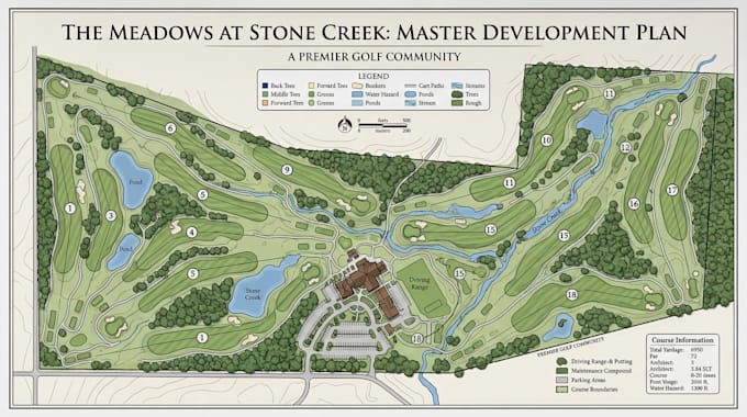
A golf course map should help players read the hole before they play it, not simply reproduce an aerial image.
I design detailed golf course, disc golf, vector, and illustrated maps that clearly communicate fairways, greens, hazards, paths, distances, and key course features.
Why you may need this:
- Give players a clear visual understanding of each hole
- Present your course professionally for signage, scorecards, or marketing
- Turn complex course layouts into attractive, easy-to-read graphics
I can provide:
- Golf Course Maps
- Disc Golf Maps
- Hole Maps
- Vector Golf Maps
- Illustrated Golf Maps
- Fairway Layouts
- Green & Tee Layouts
- Hazard Mapping
- Bunker Mapping
- Water Feature Mapping
- Cart Path Layouts
- Hole Numbering
- Distance Markers
- Course Signage Maps
- Full Course Overview Maps
Why choose me?
- Clear course layouts built for player readability
- Clean vector artwork suitable for print and digital use
- Detailed illustrations tailored to your course
Have a golf or disc golf course that needs a professional map? Send your course information, reference imagery, or survey data and lets turn the layout into a map players can understand at a glance.
Delivery style preference
Please inform the freelancer of any preferences or concerns regarding the use of AI tools in the completion and/or delivery of your order.
Get to know Urelles Dillard
Urelles Dillard
GIS Geospatial Consultant And Mapping Spatial Analysis
- FromUnited States
- Member sinceJul 2026
- Avg. response time1 hour
Languages
English
I’m a GIS & Geospatial Consultant helping clients turn complex location, terrain, and spatial data into reliable information for engineering, planning, land development, surveying, and environmental projects. I specialize in GIS mapping, ArcGIS, QGIS, spatial analysis, remote sensing, web maps, plat maps, golf course maps, LiDAR processing, terrain modeling, parcel mapping, and 2D/3D visualization. I develop practical geospatial workflows that clarify site conditions, communicate findings, and support confident project decisions.