Browse categories
Explore
Fiverr Pro
English
$
USD


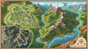
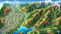
Turn raw land data into powerful, accurate, and visually stunning maps that drive real decisions!
I am a professional GIS and drone mapping specialist delivering high-precision geospatial solutions for planning, surveying, and development projects.
My Services:
Why Choose Me:
Message me before ordering to discuss your project and ensure the best results.
Please inform the freelancer of any preferences or concerns regarding the use of AI tools in the completion and/or delivery of your order.
Cartographer and GIS mapping specialist
Languages
Will the map be accurate and professional?
Yes. I use industry-standard GIS tools (ArcGIS/QGIS) and reliable geospatial data to ensure high accuracy and professional-quality results.
Can you handle complex or large projects?
Absolutely. I specialize in both small and large-scale mapping projects, including subdivision, drone orthophotos, and terrain analysis.
What if I don’t have proper data?
No problem. I can work with available data or guide you on what is needed to complete your project correctly.
Will I get editable/source files?
Yes, depending on the package, I can provide editable GIS files (QGIS/ArcGIS) or high-resolution export formats.
What if I’m not satisfied with the result?
I offer revisions based on package terms and ensure clear communication throughout the project to meet your expectations.


