Browse categories
Explore
Fiverr Pro
English
$
USD
Computer Vision and 3D Data Processing Engineer
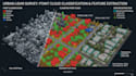
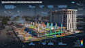
I develop custom LiDAR processing, point cloud classification, feature extraction, and 3D mapping workflows for complex spatial datasets.
I can process LiDAR and point cloud data to identify and separate important real-world features such as:
I work with Python, Open3D, NumPy, PDAL, machine learning, and custom 3D processing pipelines to turn raw spatial data into structured and usable information.
My workflows are suitable for surveying, mapping, construction, urban planning, robotics, geospatial analysis, and 3D reconstruction.
Send me your LiDAR/point cloud dataset, required classes, and desired output before ordering.
Programming language:
Python
APIs:
Amazon Rekognition
•
Google Cloud Vision API
Tools:
OpenCV
Frameworks:
Scikit-learn
•
SimpleCV
•
PyTorch


