Browse categories
English
$
USD
Connect to your AI
Need consistent GIS data rather than a new map? I clean vector layers in QGIS and document changes and unresolved issues.
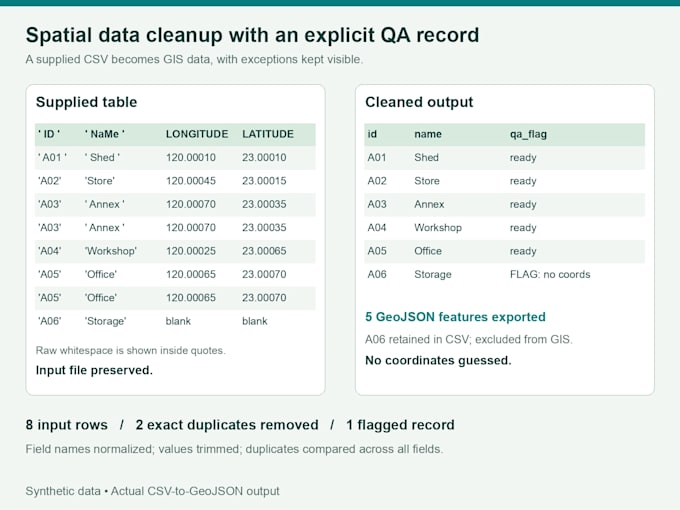
BASIC: 1 layer, up to 100 input features. Trim spaces, standardize agreed fields and remove exact duplicate records.
STANDARD: Up to 3 layers, 200 input features total. Basic cleanup, confirmed-CRS conversion and geometry checks with issue flags.
PREMIUM: Up to 5 layers, 300 input features total. Standard QA, agreed schema mapping and merging compatible layers.
Every package includes one chosen GIS output format, before/after counts, a QA summary and a flagged/excluded-records CSV. Original files stay unchanged.
Send a sample before ordering. We confirm volume, CRS, duplicate rules and format in written Fiverr messages. A layer is one dataset; Shapefile sidecars count as one layer. Caps cover all input layers combined.
GeoPackage, GeoJSON, Shapefile or KML exports depend on sample review. Coordinate CSVs require known coordinates and CRS. Missing coordinates are flagged, never guessed.
No raster processing, geocoding or guessed CRS. Complex geometry repairs, topology rebuilding and custom scripts require a separate quote.

What do I receive?
Cleaned data in one agreed GIS format, before/after counts, a short QA summary and a CSV of flagged or excluded records with reasons. If no issues are found, the issue log is empty. Original source files remain unchanged.
What counts as a layer and a feature?
One vector dataset is one layer. Shapefile sidecar files together count as one layer. Feature limits cover all input layers combined before deduplication. Each coordinate-CSV row counts toward the cap. File size and geometry complexity are checked from your sample.
Which formats and coordinate systems can you handle?
Sample-reviewed vector inputs and coordinate CSVs are accepted. Choose one output: GeoPackage, GeoJSON, Shapefile or KML, subject to format limits. Source and target CRS must be confirmed for conversion; I do not guess an unknown CRS.
How are duplicates removed?
We agree comparison fields and normalization first. Basic removes exact duplicate records under those rules. Similar names, nearby coordinates, overlapping shapes or repeated IDs alone are not automatic duplicates. Fuzzy or spatial deduplication needs a separate quote.
Do you fix every geometry or missing coordinate?
Standard and Premium check geometry and flag issues. Complex repairs and topology rebuilding require a separate quote. Missing coordinates are flagged and excluded from spatial export when necessary, with their records retained in the issue CSV. I do not invent locations.
What does Premium schema mapping and merging cover?
We agree output fields and compatible field types before work begins. Compatible layers must have an agreed common CRS and geometry type. I flag conversion problems. Unclear business rules, complex type conversions, geometry rebuilding and custom scripts are quoted separately.
What counts as a revision?
A revision corrects delivery against the agreed cleanup rules, fields and original inputs. New data, added layers, a new CRS or output format, changed duplicate rules or extra operations change the scope and may require a separate quote.
Do we need a call, and should I contact you first?
Please send sample files before ordering so I can confirm scope and availability. I work through written Fiverr messages with agreed rules and delivery notes. These packages do not require video calls. Data sourcing, maps, raster work and geocoding are excluded.
