Browse categories
Explore
Fiverr Pro
English
$
USD


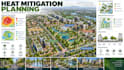
I will create professional heat mitigation planning layouts and sustainable urban development concepts designed to communicate strategies for creating cooler, greener, and more climate-responsive urban environments.
I can develop heat mitigation concepts incorporating urban tree canopies, shaded pedestrian corridors, green infrastructure, parks, green roofs, permeable surfaces, water features, cooling spaces, reflective-surface concepts, ventilation corridors, and climate-responsive public spaces.
Layouts can also communicate heat-risk areas, heat exposure patterns, vulnerable urban zones, cooling networks, green corridors, and relationships between existing development and proposed mitigation strategies.
Whether you have GIS data, temperature information, an existing site plan, aerial imagery, CAD drawings, survey information, maps, or a rough concept, I can organize the available information into a professional planning presentation.
The resulting graphics can support sustainable development proposals, climate adaptation studies, urban planning reports, environmental presentations, feasibility studies, academic projects, design reviews, and professional portfolios.
Fiverr does not screen freelancers in this category. Please verify qualifications and discuss requirements with the freelancer before ordering, including any preferences regarding the use of AI tools.
Real Estate Development Planner Site Yield Feasibility Land Development
Languages
What is included in a heat mitigation planning layout?
Layouts can show shade networks, tree canopies, green corridors, parks, cooling spaces, permeable surfaces, water features, ventilation corridors, and other climate-responsive planning strategies.
Can you create urban heat mapping concepts?
Yes. Heat-risk and temperature-related information can be translated into clear spatial maps and planning graphics when appropriate data is provided.
Can you incorporate green infrastructure?
Yes. Green corridors, urban trees, landscaped areas, green spaces, permeable surfaces, and other green infrastructure strategies can be incorporated into the planning concept.
