Browse categories
Explore
Fiverr Pro
English
$
USD


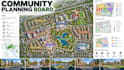
I will design professional community planning presentation boards for urban development projects, transforming complex planning information into clear and engaging architectural graphics.
I create presentation boards for residential communities, neighborhood developments, mixed-use districts, community regeneration projects, public developments, and large-scale urban planning concepts.
Your board can showcase community master plans, housing areas, commercial zones, community facilities, schools, parks, public spaces, pedestrian networks, cycling routes, road systems, parking, green infrastructure, amenities, zoning, site analysis, and development diagrams.
I can work from CAD drawings, GIS information, surveys, PDFs, sketches, maps, aerial imagery, architectural plans, or existing planning concepts and organize them into a cohesive professional presentation.
The finished board can be structured for development proposals, planning presentations, feasibility studies, design reviews, academic projects, public consultations, investor presentations, competitions, and professional portfolios.
My focus is on clear information hierarchy, strong architectural graphics, readable
Fiverr does not screen freelancers in this category. Please verify qualifications and discuss requirements with the freelancer before ordering, including any preferences regarding the use of AI tools.
Real Estate Development Planner Site Yield Feasibility Land Development
Languages
What types of community planning projects can you present?
I can create boards for residential communities, neighborhoods, mixed-use developments, regeneration projects, public developments, and larger urban development concepts.
What can be shown on a community planning board?
Boards can include master plans, housing zones, community facilities, parks, public spaces, commercial areas, pedestrian networks, roads, parking, zoning, green infrastructure, and development diagrams.
Can you work with existing planning drawings?
Yes. I can use CAD drawings, GIS data, surveys, PDFs, sketches, maps, aerial images, and existing master plans as source material.
