Browse categories
Explore
Fiverr Pro
English
$
USD
I will digital twin map illustration and smart city visualization, urban modern map


WitKaren
About this gig
Hello
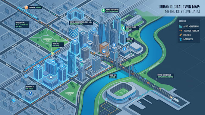
Are you looking for a professional digital twin map illustration for smart cities, real estate developments, infrastructure projects, industrial facilities, or urban planning? I create highly detailed visual representations that showcase buildings, roads, utilities, green spaces, and assets in a modern map format.
Perfect for presentations, investor proposals, planning documents, websites, and development marketing.
My Service Includes
- Digital twin maps
- Smart city visuals
- Infrastructure maps
- City Map
- Urban Map
- Urban planning illustrations
- Vector files
- Commercial use
Why Choose Me
- Modern map design
- High quality visuals
- Fast delivery
- Professional communication
- Editable source files
Let's bring your project to life with a digital twin style map.
Delivery style preference
Please inform the freelancer of any preferences or concerns regarding the use of AI tools in the completion and/or delivery of your order.
Get to know WitKaren
WitKaren
GIS Mapping, Vector Map Design, Site Plans, Interactive Maps, Cartography
- FromUnited Kingdom
- Member sinceJun 2026
- Avg. response time1 hour
Languages
English, Spanish
We are a professional mapping team specializing in Vector Map Design, GIS Mapping, Cartography, Site Planning, Property Mapping, Tourist Mapping, Wayfinding Design, Interactive Maps, Isometric Map Illustration, Navigation Systems, and Digital Mapping. We help developers, resorts, tourism businesses, municipalities, real estate professionals, and organizations transform complex geographic information into visually engaging, accurate, and easy-to-understand maps for print, web, marketing, planning, and navigation purposes.

