I will draft topographic maps, boundary surveys, and contour plans

Y
yohanbawanthawa
Y
yohanbawanthawa
YOHAN

About this gig

Since you are focusing on the technical synergy between AutoCAD and Civil 3D, your description needs to highlight accuracy, data integrity, and professional standards.

Below is a high-converting description template. You can copy and paste this, but make sure to fill in the bracketed info with your specific details.


Gig Description

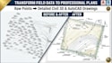
Transform Your Field Data into Professional Civil 3D & AutoCAD Drawings!

Are you looking for a precise and reliable drafting partner for your land surveying or civil engineering projects? I provide high-quality Civil 3D modeling and AutoCAD drafting services, specializing in turning raw field data into clean, industry-standard survey plans.

With extensive experience in processing topographic data, I ensure that every contour, boundary, and point is represented with 100% accuracy to help your project move forward without errors.

What I Offer:

  • Topographic Surveys: Creating detailed maps with accurate contour intervals and surface modeling.
  • Boundary & Cadastral Mapping: Precise drafting of property lines, easements, and setbacks.
  • Point Data Processing: Importing and managing PNEZD (CSV/TXT) data with custom description keys.
  • ALTA/NSPS Survey Plans: Draftin
Delivery style preference

Please inform the freelancer of any preferences or concerns regarding the use of AI tools in the completion and/or delivery of your order.

Get to know YOHAN

YOHAN

Geospatial Analyst

5.0(2)
  • FromSri Lanka
  • Member sinceMay 2021
  • Avg. response time2 hours
  • Last delivery4 years
  • Languages

    English, Sinhala
I am a GIS Analyst with a BSc (Hons) in Surveying Science specializing in Geographic Information Systems from Sabaragamuwa University of Sri Lanka. I have hands-on experience in GIS mapping, spatial analysis, digitizing, and GNSS-based field data collection. I have worked on real-world projects involving road surveys, land use mapping, and infrastructure data processing using tools like QGIS, ArcGIS, and GPS/GNSS systems. I focus on delivering accurate, clean, and professional GIS outputs tailored to client needs with fast turnaround and attention to detail.